Apa itu Presisi dan Akurasi?
Presisi (Precision) dan Akurasi (Accuracy) merupakan dua konsep dasar dalam dunia pengukuran, khususnya dalam bidang survei, pemetaan, dan teknik. Meskipun sering digunakan secara bersamaan, keduanya memiliki makna yang berbeda dan tidak dapat saling menggantikan. Pemahaman yang tepat mengenai perbedaan antara presisi dan akurasi sangat penting untuk menghasilkan data yang valid dan dapat dipercaya sebagai dasar pengambilan keputusan. Tanpa pemahaman yang baik, data yang terlihat rapi dan konsisten dapat menyesatkan apabila tidak merepresentasikan kondisi sebenarnya di lapangan.
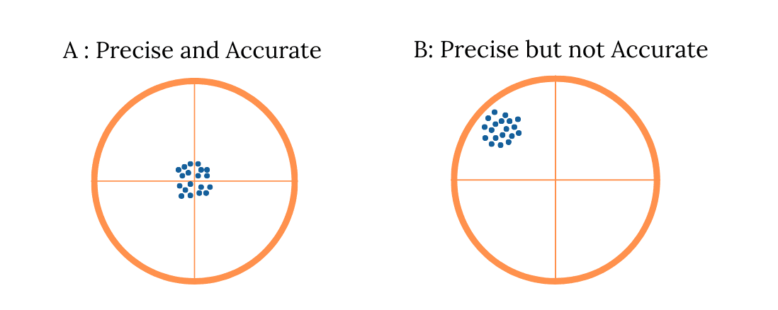
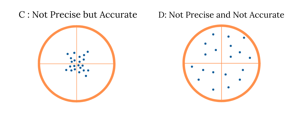
Presisi (precision) mengacu pada tingkat konsistensi dari suatu alat atau metode pengukuran. Artinya, jika suatu pengukuran dilakukan berulang kali dalam kondisi yang sama dan menghasilkan nilai yang hampir identik, maka hasil tersebut dianggap memiliki presisi yang tinggi. Presisi menunjukkan stabilitas dan keandalan metode atau instrumen pengukuran yang digunakan, terlepas dari seberapa dekat nilai tersebut dengan nilai sebenarnya. Oleh karena itu, suatu hasil pengukuran dapat memiliki presisi yang tinggi namun belum tentu akurat apabila nilainya masih jauh dari nilai sebenarnya.
Sebaliknya, akurasi (accuracy) adalah ukuran yang menunjukkan seberapa dekat hasil pengukuran terhadap nilai sebenarnya atau nilai referensi. Pengukuran yang akurat berarti hasilnya mendekati nilai yang benar secara absolut, meskipun hasil pengukuran berulang belum tentu selalu konsisten. Dalam praktiknya, akurasi sangat dipengaruhi oleh kesalahan sistematis, seperti kalibrasi instrumen yang tidak tepat, metode pengukuran yang keliru, atau asumsi perhitungan yang tidak sesuai. Dengan demikian, akurasi lebih menekankan pada ketepatan nilai hasil pengukuran.
Untuk mempermudah pemahaman, bayangkan seseorang sedang memanah ke arah target. Jika semua anak panah mengenai titik yang sama tetapi jauh dari pusat target, maka hasil tersebut sangat presisi namun tidak akurat. Sebaliknya, jika anak panah tersebar namun rata-rata berada di sekitar pusat target, maka hasilnya lebih akurat tetapi kurang presisi. Kondisi ideal adalah ketika semua anak panah mengenai titik pusat target secara konsisten, yang berarti presisi dan akurasi tercapai secara bersamaan. Analogi ini sangat relevan untuk menggambarkan pentingnya kedua aspek tersebut dalam dunia pengukuran.
Dalam kegiatan survei dan pemetaan, presisi dan akurasi sangat menentukan kualitas data spasial yang dihasilkan. Saat menggunakan alat seperti GPS atau GNSS, presisi menunjukkan apakah posisi yang diperoleh stabil dari waktu ke waktu, sedangkan akurasi menunjukkan apakah titik tersebut benar-benar merepresentasikan posisi sebenarnya di permukaan bumi. Tanpa presisi yang baik, data akan tersebar dan sulit dipercaya. Sebaliknya, tanpa akurasi yang tinggi, data mungkin terlihat rapi tetapi tidak dapat digunakan sebagai dasar perencanaan atau pengambilan keputusan yang strategis.
Kesalahan pengukuran dapat memengaruhi baik presisi maupun akurasi. Kesalahan acak (random error), seperti cuaca atau gangguan sinyal, umumnya memengaruhi presisi karena menyebabkan hasil pengukuran menjadi tidak stabil. Sementara itu, kesalahan sistematis (systematic error), seperti offset instrumen atau kesalahan metode, akan memengaruhi akurasi. Oleh karena itu, sangat penting untuk melakukan pengendalian mutu (quality control) secara menyeluruh pada seluruh proses survei, mulai dari pemeriksaan alat dan metode yang digunakan hingga validasi hasil akhir, agar kualitas data tetap terjamin.
Presisi dan akurasi tidak hanya penting dalam pekerjaan teknis, tetapi juga sangat berpengaruh terhadap pengambilan keputusan. Dalam proyek pembangunan, seperti pemetaan batas lahan, perhitungan volume, atau penilaian aset, data yang tidak akurat atau tidak konsisten dapat menimbulkan konflik, pemborosan anggaran, bahkan kesalahan desain. Karena itu, perusahaan atau instansi yang bergerak di bidang survei dan pemetaan harus mampu memastikan bahwa data yang dihasilkan memenuhi standar presisi dan akurasi yang dibutuhkan oleh pengguna.
Dengan demikian, dapat disimpulkan bahwa presisi dan akurasi merupakan dua aspek yang saling melengkapi dalam menghasilkan data yang berkualitas tinggi. Keduanya tidak dapat berdiri sendiri dan harus diperhatikan secara bersamaan dalam setiap proses pengukuran. Dengan data yang presisi dan akurat, setiap keputusan berbasis data akan menjadi lebih tepat sasaran, efisien, dan minim risiko, baik pada skala proyek kecil maupun besar. Inilah sebabnya mengapa prinsip presisi dan akurasi selalu menjadi fondasi utama dalam dunia pengukuran profesional.