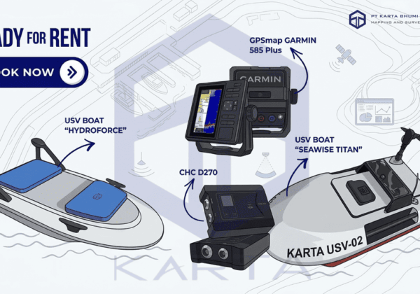
KONSEP SBES
SBES pertama kali dikembangkan pada awal abad ke-20 sebagai pengganti lead line (tali bandul) yang sebelumnya digunakan untuk mengukur kedalaman laut. Seiring dengan perkembangan teknologi elektronik dan komputer, SBES kini mampu menghasilkan data yang lebih presisi, terintegrasi dengan sistem navigasi satelit (GNSS/RTK), serta dapat langsung diolah menjadi profil dasar perairan.
Dalam perkembangannya, SBES tetap banyak digunakan karena biayanya lebih rendah dibandingkan dengan Multibeam Echo Sounder (MBES). Hal ini menjadikan SBES sangat cocok digunakan pada proyek yang tidak memerlukan cakupan data penuh, seperti survei kanal, sungai, atau perairan dangkal yang relatif kecil.
Komponen Utama SBES (Single Beam Echo Sounder)
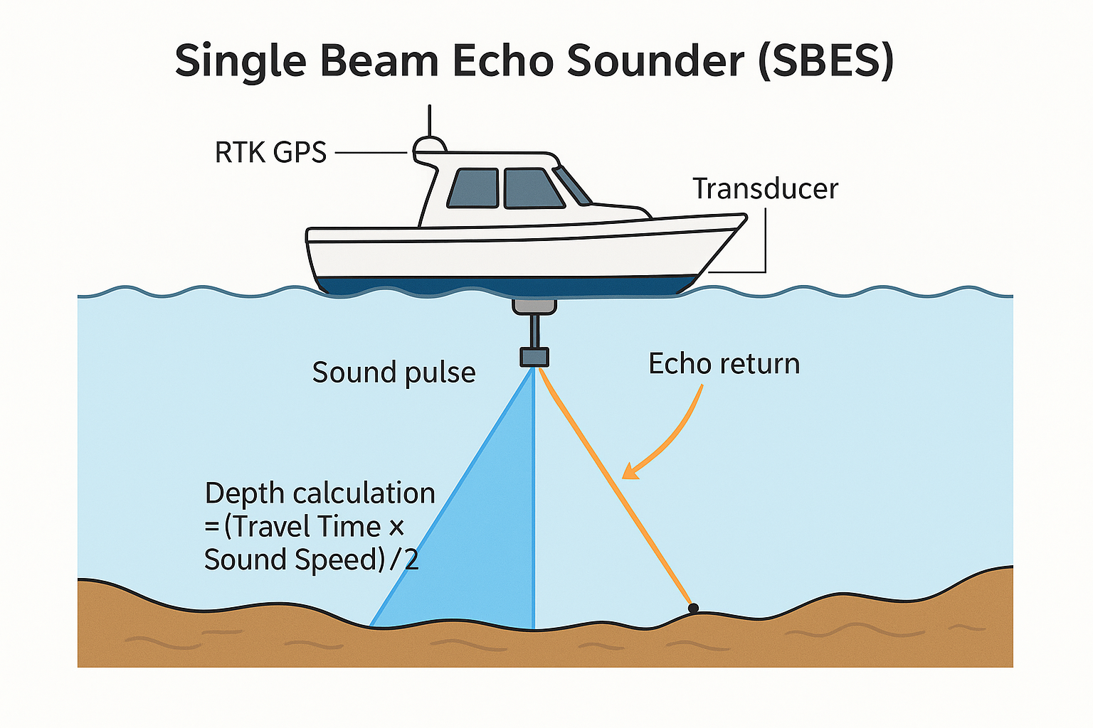
1. Transduser (Transducer)
Berfungsi sebagai pemancar dan penerima sinyal suara (gelombang akustik). Perangkat ini dipasang di bagian bawah perahu atau USV (Unmanned Surface Vehicle) agar dapat berinteraksi langsung dengan kolom air.
2. Unit Transceiver / Prosesor
Berfungsi mengubah sinyal listrik menjadi gelombang suara saat pemancaran, dan sebaliknya mengubah pantulan gelombang suara (echo) menjadi sinyal listrik saat penerimaan. Unit ini juga menghitung waktu tempuh sinyal untuk menghasilkan nilai kedalaman.
3. Receiver GPS / RTK
Berfungsi menyediakan koordinat posisi horizontal sehingga data kedalaman dapat terintegrasi dengan lokasi pengukuran secara akurat.
4. Unit Tampilan dan Perekaman (Display & Recording Unit)
Menampilkan pembacaan kedalaman secara real-time serta menyimpan data hasil pengukuran untuk analisis lebih lanjut.
Metode Penggunaan SBES (Single Beam Echo Sounder)
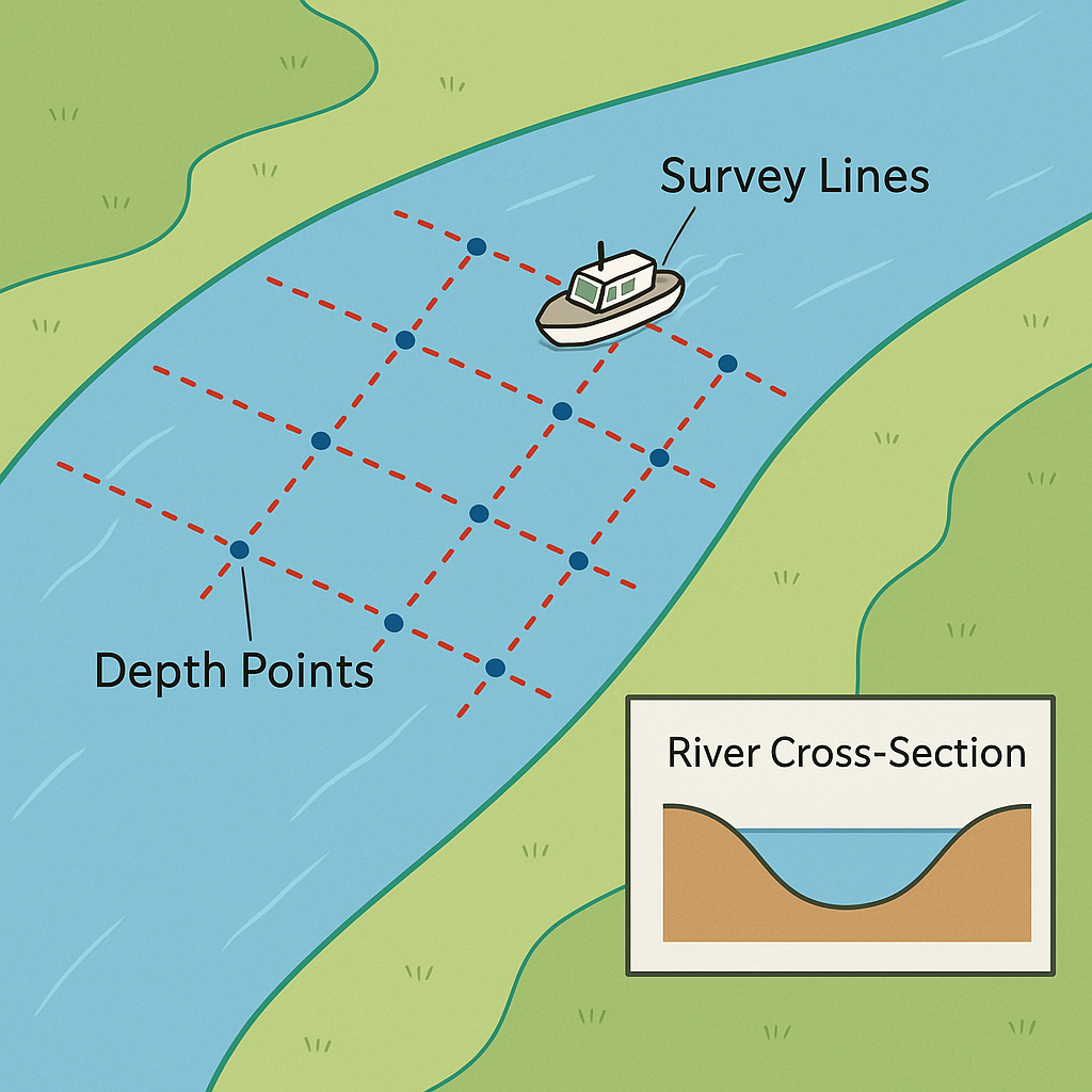
1. Perencanaan Jalur Survei (Survey Path Planning)
Jalur pergerakan kapal harus direncanakan secara sejajar dan sistematis untuk mencakup seluruh area survei, sehingga data kedalaman yang diperoleh dapat merepresentasikan kondisi dasar perairan secara menyeluruh.
2. Koreksi Kecepatan Suara (Sound Speed Correction)
Koreksi dilakukan menggunakan metode bar check atau sensor CTD (Conductivity, Temperature, Depth) untuk memperhitungkan variasi kecepatan rambat gelombang suara di dalam air yang dipengaruhi oleh temperatur, salinitas, dan tekanan.
3. Pengambilan Data (Data Collection)
Perahu atau USV (Unmanned Surface Vehicle) bergerak mengikuti jalur survei yang telah direncanakan, sementara sistem SBES merekam data kedalaman secara kontinu, biasanya setiap detik.
4. Pengolahan Data (Data Processing)
Data yang telah dikumpulkan kemudian diolah menjadi profil penampang dasar perairan (cross section) atau peta batimetri sederhana untuk keperluan analisis lebih lanjut.
Kelebihan SBES (Single Beam Echo Sounder)
Efisien dan Ekonomis
Memiliki biaya operasional yang rendah sehingga cocok untuk survei skala kecil hingga menengah.
Mudah Digunakan
Instalasinya relatif sederhana pada perahu maupun USV.
Cocok untuk Perairan Dangkal
Bekerja dengan baik di sungai, kanal, waduk, dan rawa dengan kedalaman sekitar 1–50 meter.
Terintegrasi dengan GIS
Data kedalaman dapat dengan mudah dikombinasikan dengan data topografi darat untuk analisis yang lebih terpadu.
Keterbatasan SBES (Single Beam Echo Sounder)
Cakupan Terbatas
SBES hanya menghasilkan data kedalaman tepat di bawah jalur lintasan kapal.
Kurang Efisien untuk Area Luas
Untuk memperoleh gambaran tiga dimensi dasar perairan, diperlukan jalur survei yang rapat sehingga proses survei menjadi lebih lama.
Dipengaruhi Kondisi Perairan
Kondisi seperti gelombang, tingkat kekeruhan air, atau adanya gelembung udara dapat mempengaruhi akurasi hasil pengukuran.
Aplikasi SBES (Single Beam Echo Sounder)
Survei Kanal dan Irigasi
Digunakan untuk memantau sedimentasi dan kedalaman saluran guna mendukung operasional pengelolaan air.
Pengelolaan Rawa dan Kolam
Membantu dalam perencanaan jalur perairan serta pengelolaan area budidaya perikanan.
Survei Sungai
Digunakan untuk menentukan profil dasar sungai sebagai dasar perencanaan pembangunan jembatan atau tanggul.
Dukungan Energi dan Infrastruktur
Digunakan dalam studi awal untuk pembangunan bendungan, pelabuhan, maupun proyek reklamasi.
Pemantauan Lingkungan
Digunakan untuk memantau perubahan morfologi dasar perairan akibat proses erosi maupun sedimentasi.
SBES merupakan solusi praktis untuk survei batimetri yang membutuhkan kecepatan, efisiensi, dan ketelitian pada perairan dangkal. Meskipun memiliki keterbatasan pada cakupan data yang bersifat linear, data yang dihasilkan tetap sangat bernilai sebagai dasar perencanaan teknis, pemantauan lingkungan, serta pengelolaan sumber daya air.
Integrasi SBES dengan GNSS RTK dan perangkat GIS menjadikannya sebagai instrumen yang sangat bermanfaat dalam dunia survei modern, terutama untuk menghasilkan data kedalaman yang terintegrasi dengan informasi spasial secara akurat.
#SBES #Batimetri #PointCloud #Geospasial #Pemetaan3D #PemetaanDrone #Survei #Pemetaan #Topografi #DataSpasial #KonsultanPemetaan #GIS #AnalisisGIS