Penentuan Kedalaman Laut dengan Koreksi Pasang Surut
Dalam survei hidrografi, salah satu tantangan terbesar adalah menentukan kedalaman laut secara akurat, meskipun muka air laut terus berubah akibat pasang surut. Oleh karena itu, diperlukan suatu sistem referensi yang konsisten untuk menstandarkan data kedalaman yang diperoleh pada waktu dan lokasi yang berbeda.
Prinsip Dasar Pengukuran
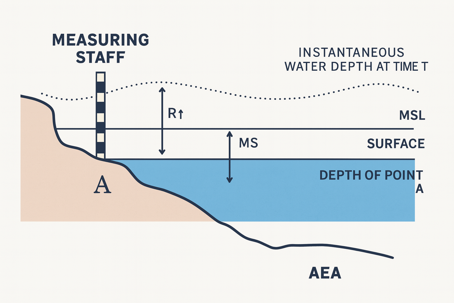
Ilustrasi tersebut menunjukkan bagaimana menentukan kedalaman pada suatu titik di laut, misalnya Titik A. Di sisi kiri terdapat tide staff (rambu ukur pasang surut) yang digunakan untuk membaca tinggi muka air laut secara langsung pada saat pengamatan. Karena muka air laut tidak pernah konstan naik saat pasang dan turun saat surut pembacaan ini sangat penting untuk mencatat kondisi tinggi muka air pada waktu tertentu.
Garis lengkung putus-putus di bagian atas menggambarkan posisi muka air laut pada waktu T, yaitu saat pengamatan dilakukan. Karena data ini bersifat sangat dinamis, maka diperlukan suatu standar referensi jangka panjang sebagai acuan untuk menormalkan atau menstandarkan hasil pengukuran.
Mean Sea Level (MSL)
Untuk menormalkan data, digunakan garis horizontal yang disebut Mean Sea Level (MSL). MSL merupakan rata-rata tinggi muka laut yang dihitung dari data pasang surut jangka panjang (biasanya 19 tahun menurut standar internasional, atau beberapa bulan hingga beberapa tahun untuk survei praktis). Dengan adanya MSL, kita memperoleh gambaran umum mengenai rata-rata muka air laut sehingga proses koreksi data kedalaman dapat dilakukan dengan lebih mudah.
Komponen Utama dalam Koreksi
Dari ilustrasi tersebut, terdapat beberapa komponen penting:
R → Tinggi muka air laut yang dibaca dari rambu ukur pasang surut (tide staff) pada saat pengamatan.
MS → Jarak vertikal dari datum surut terendah (Chart Datum / Lowest Astronomical Tide) hingga MSL.
Zo → Koreksi muka air laut terhadap datum surut. Koreksi ini penting karena setiap hasil pengamatan kedalaman harus dikonversi ke dalam sistem referensi yang sama.
AEA (Depth Datum / Chart Datum) → Merupakan acuan dasar untuk seluruh pengukuran kedalaman. Dengan menggunakan Chart Datum, seluruh data kedalaman dapat dikoreksi ke satu referensi yang sama sehingga menghasilkan data yang konsisten.
Proses Penentuan Kedalaman di Titik A
Langkah-langkah untuk menentukan kedalaman di Titik A adalah sebagai berikut:
Mengukur jarak vertikal dari permukaan air laut saat pengamatan hingga dasar laut menggunakan peralatan akustik seperti Single Beam Echo Sounder (SBES) atau Multibeam Echo Sounder (MBES).
Secara bersamaan membaca tinggi muka air laut (R) menggunakan tide staff atau sensor pasang surut otomatis.
Melakukan koreksi terhadap hasil pengukuran kedalaman menggunakan nilai Zo, yaitu selisih ketinggian antara muka air laut saat pengamatan dengan Chart Datum.
Hasil akhir adalah kedalaman standar yang telah direferensikan terhadap Chart Datum (AEA), sehingga data kedalaman dapat dibandingkan dengan pengukuran lain yang dilakukan pada waktu maupun lokasi yang berbeda.
Pentingnya Koreksi Pasang Surut
Tanpa koreksi ini, data kedalaman akan mengalami bias akibat perubahan pasang surut. Sebagai contoh, pengukuran yang dilakukan saat air pasang dapat menghasilkan kedalaman yang tampak lebih dangkal dibandingkan pengukuran saat air surut, meskipun dasar laut berada pada titik yang sama.
Dengan melakukan koreksi terhadap datum, data kedalaman menjadi konsisten, aman digunakan untuk keperluan navigasi, serta dapat diintegrasikan ke dalam peta laut (nautical charts) dan hasil survei batimetri.
Manfaat dalam Praktik
Navigasi: Kapal dapat berlayar dengan aman karena peta kedalaman selalu mengacu pada datum yang sama.
Perencanaan Infrastruktur: Menyediakan data yang akurat untuk pembangunan dermaga, bendungan, jembatan, maupun proyek reklamasi.
Pengelolaan Lingkungan: Digunakan untuk memantau perubahan morfologi dasar perairan, proses sedimentasi, serta erosi pantai.
#PasangSurut #TidalObservation #TidalCorrection #HydrographicSurvey #Bathymetry #SBES #OceanSurvey #MarineSurvey #SeaLevel #MeanSeaLevel #ChartDatum #Hydrography #Geospatial #Surveying #GIS #MarineMapping #CoastalMonitoring #WaterLevel #OceanMapping #SpatialData