LiDAR vs Photogrammetry : Which technology is best for 3D Mapping?
When it comes to surveying and mapping, LiDAR and photogrammetry are often compared. Both technologies produce accurate 3D maps data, point clouds, and digital terrain models, but they work in very different ways.
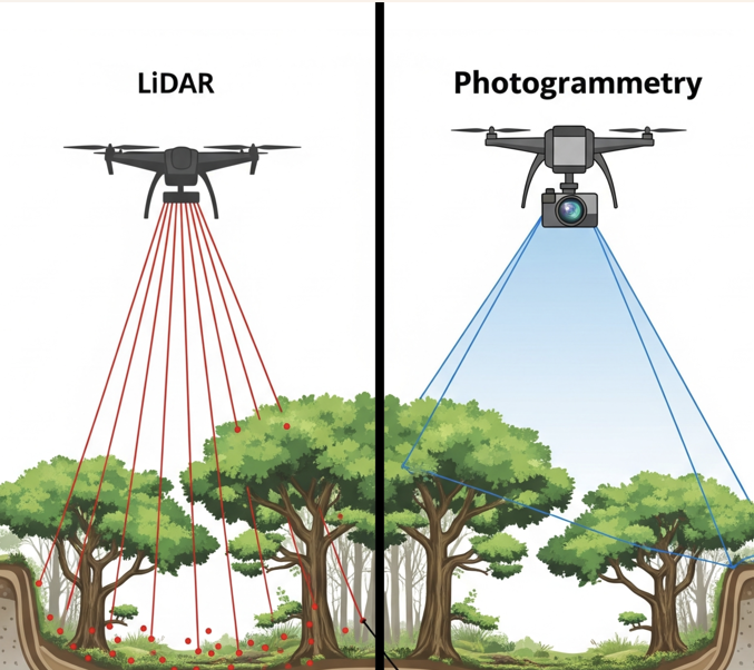
LiDAR or Light Detection and Ranging uses laser beams to measure distances. LiDAR sensors send out pulses of light per seconds and records how long they take to return. This creates a dense and highly accurate 3D point cloud that can penetrate vegetation and captures ground surfaces/elevation. LiDAR is widely used in topographic mapping, flood modeling, and forestry where precision is critical.
On the other side, Photogrammetry uses overlapping images taken from drones and camera that capture multiple perspective. This creates detailed 3D model and orthophotos with rich colors and textures. Photogrammetry is widely used in construction, mining, and visual inspections because it delivers both measurement data and realistic imagery.
LiDAR gear is laser-based, heavier, and pricier, while photogrammetry uses cameras; so it’s lighter and more budget-friendly. At the end of the day, it really depends on what your project needs. Not sure which one’s the right fit? Let’s discuss and find the best solution together.
#LiDAR #UAVLiDAR #Photogrammetry #PointCloud #GeoSpatial Tagar#3DMapping #DroneMapping #Surveying #Mapping #Topography #SpatialData #MappingConsultant #GIS #GISAnalysis #Forestry